
 Be the first to rate
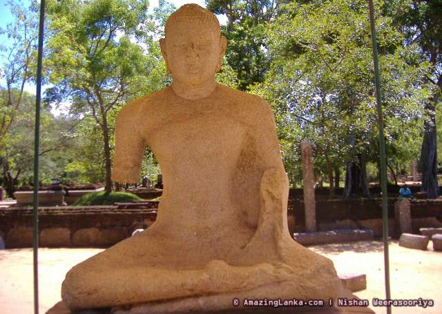
This Buddha Statue belongs to the Abayagiri Aramic Complex. This site is popularly known as the 2nd Samadhi Statue of Anuradhapura. Though the origin of this statue is unknown, from the style of execution it is thought that the Buddha is in the Vitharka Posture and belongs to the 6th-8th centuries. According to Anuradha Seneviratna, this statue clearly shows the Gupta School of Sculpture.
Ruins of other buildings including a Bodhigara can be seen at this site.


References
- Ancient Anuradhapura – The Monastic City by Prof. Anuradha Seneviratna (1994)
Also See
Map of the Second Samadhi Statue at Anuradhapura
The map above also shows other places of interest within a approximately 20 km radius of the current site. Click on any of the markers and the info box to take you to information of these sites
Zoom out the map to see more surrounding locations using the mouse scroll wheel or map controls.
Driving Directions to Anuradhapura
Anuradhapura can be reached through many routes from Colombo. The two main routes are through Puttalam (Puttalama) and through Kurunegala. Travelling from Puttalam, you will pass the scenic Wilpattu area. From Kurunegala, there are two main routes to Anuradhapura. The most common route is through Dambulla. The other route is through Galgamuwa. Out of all the routes, the most commonly used is the Kurunegala-Dambulla route (Route 2).
| Route 01 from Colombo to Anuradhapura | Route 02 from Colombo to Anuradhapura |
| Through : Negombo – Chilaw – Puttalam Distance from Colombo : 210 km Travel time : 4.30- 5.00 hours Driving Directions : see on Google map | Through : Katunayake Expressway – Central Expressway – Kurunegala – Dambulla Distance from Colombo : 223 km Travel Time : 4.30- 5.00 hours Driving Directions : see on Google maps |
| Route 03 from Colombo to Anuradhapura | Route from Kandy to Anuradhapura |
| Through : Katunayake Expressway – Narammala – Wariyapola – Padeniya – Thambuthegama Distance from Colombo :203 km Travel Time : 4.30- 5.00 hours Driving Directions : see on Google map | Through : Katugastota – Matale – Dambulla Distance from Colombo :136 km Travel Time : 3.5 hours Driving Directions : see on Google map |
0-09 m (81) 10-19 m (71) 20-29 m (42) 30-39 m (47) 40-49 m (23) 50-99 m (44) Ambalama (153) Ancient Anicuts (31) Ashtapala Bodhi (5) Attraction Article (3) Attractions (200) Beaches (7) Biosphere Reserves (3) Botanical Gardens (3) Bridges (34) Caving (7) Church (11) Cities (9) Destinations (16) Dethis Pala Bodhi (15) Devalaya (41) Flora and Fauna (44) Forts (49) Heritage (1606) Heritage Article (28) Historic Events (5) History (7) Hot Springs (9) Hydro Heritage (85) Irrigation Article (4) Islands (15) Kovil (25) Lighthouses (27) Memorials (28) Mile Posts (6) Mosque (3) Museums (8) National Parks (22) over 100 m (15) Pabbatha Vihara (10) Personalities (7) Pillar/Slab Inscriptions (35) Pre Historic Burial Sites (19) Prehistory (37) Ravana (12) Reservoirs (44) Ruins in Wilpattu (5) Ruins in Yala (24) Santuaries (7) Sluice Gates (11) Stone Bridges (18) Strict Nature Reserves (3) Survey Towers (13) Tampita Vihara (239) Travel (3) View Points (9) Walawwa (12) Waterfalls (375) Wildlife Article (24) Yathuru Pokuna (4)
Abhayagiri Monastery (19) Ampara District (191) Anuradhapura District (194) Badulla District (107) Batticaloa District (19) Colombo District (63) Galle District (58) Gampaha District (49) Hambantota District (99) Jaffna District (69) Kalutara District (47) Kandy District (178) Kegalle District (148) Kilinochchi District (11) Kingdom of Anuradhapura (80) Kingdom of Kandy (14) Kingdom of Polonnaruwa (55) Kurunegala District (150) Maha Vihara (14) Mannar District (47) Mannar Island (10) Matale District (72) Matara District (33) Mihintale (22) Monaragala District (72) Mullaitivu District (19) Nuwara Eliya District (109) Polonnaruwa District (107) Puttalam District (28) Ratnapura District (146) Trincomalee District (44) Vavuniya District (28) z Jaffna 1 (20) z Jaffna 2 (22) z Jaffna 3 (11)