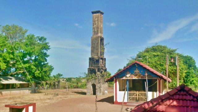
This old survey tower is located in Ilukpakadai 04th Gramasewaka division of Manthai West Divisional Secretariat. To reach the temple travel 30 km from Mannar on Poonareen road, turn left at Ilukpakadawai junction and travel 200 meters on Padauthura road, this tower can be seen near a Hindu Kovil.
This tower is between 12-13 meters high. According to legend, it was built by the Portuguese. However, most of these Survay towers found in the country were built during the British Era. The first floor of this tower is 2.31 meters in length and width and consists of five equilateral floors that gradually get smaller.
This first floor was built using limestone blocks measuring 52 cm long and 18 cm wide, and burnt bricks were used to make the remaining floors. A 1.7 meter high and 78 cm wide arched entrance has been created on the west and east faces of the first part. After entering through this arch, a square horizontal opening is made from the centre point of the tower to the top, which is 21 cm in length and width.
The third floor is shorter than the first and second floors. The fourth and fifth floors are built taller than the first three floors. Locals say that there was a wall around this tower in the past which has been destroyed. The tower was gazetted as an archaeological monument on 25 March 2016.
Another similar measuring tower can be seen after 4 km on this Mannar-Jaffna road after turning to Thiruketheeswaram Kovil. The tower consists of four floors.
References
- අසංග, එම්. වී. පී. කේ. සහ නිශාන්ත, අයි. පී. ඇස්., 2018. මන්නාරම දිස්ත්රික්කය – පුරාවිද්යා දෙපාර්තමේන්තුව. 1වන සංස්කරණය. කොළඹ: රජයේ මුද්රණ දෙපාර්තුමේන්තුව,පිටු .113-114.
Also See
Map of Iluppakadavai Padavuthurai Survey Tower
The map above also shows other places of interest within a approximately 20 km radius of the current site. Click on any of the markers and the info box to take you to information of these sites
Zoom out the map to see more surrounding locations using the mouse scroll wheel or map controls.
Traveling Directions to Iluppakadavai Padavuthurai Survey Tower
| From Mannar to Iluppakadavai Padavuthurai Survey Tower |
| Via : Punareen Road Total distance : 30 km Duration : 30 minutes Time taken: About 30 minutes Driving Directions : View on Google Maps |
0-09 m (81) 10-19 m (71) 20-29 m (42) 30-39 m (47) 40-49 m (23) 50-99 m (44) Ambalama (153) Ancient Anicuts (31) Ashtapala Bodhi (5) Attraction Article (3) Attractions (200) Beaches (7) Biosphere Reserves (3) Botanical Gardens (3) Bridges (34) Caving (7) Church (11) Cities (9) Destinations (16) Dethis Pala Bodhi (15) Devalaya (41) Flora and Fauna (44) Forts (49) Heritage (1608) Heritage Article (28) Historic Events (5) History (7) Hot Springs (9) Hydro Heritage (85) Irrigation Article (4) Islands (15) Kovil (25) Lighthouses (27) Memorials (30) Mile Posts (6) Mosque (3) Museums (8) National Parks (22) over 100 m (15) Pabbatha Vihara (10) Personalities (7) Pillar/Slab Inscriptions (35) Pre Historic Burial Sites (19) Prehistory (37) Ravana (12) Reservoirs (44) Ruins in Wilpattu (5) Ruins in Yala (24) Santuaries (7) Sluice Gates (11) Stone Bridges (18) Strict Nature Reserves (3) Survey Towers (13) Tampita Vihara (239) Travel (3) View Points (9) Walawwa (12) Waterfalls (375) Wildlife Article (24) Yathuru Pokuna (4)
Abhayagiri Monastery (19) Ampara District (191) Anuradhapura District (194) Badulla District (107) Batticaloa District (19) Colombo District (63) Galle District (59) Gampaha District (49) Hambantota District (99) Jaffna District (69) Kalutara District (47) Kandy District (179) Kegalle District (148) Kilinochchi District (11) Kingdom of Anuradhapura (80) Kingdom of Kandy (14) Kingdom of Polonnaruwa (55) Kurunegala District (150) Maha Vihara (14) Mannar District (47) Mannar Island (10) Matale District (72) Matara District (33) Mihintale (22) Monaragala District (72) Mullaitivu District (19) Nuwara Eliya District (109) Polonnaruwa District (107) Puttalam District (28) Ratnapura District (146) Trincomalee District (44) Vavuniya District (28) z Jaffna 1 (20) z Jaffna 2 (22) z Jaffna 3 (11)


