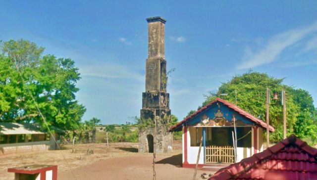
This island called by the Portuguese ilha das Vacas, had a fort built by them. The Dutch called it Delft Island. The Tamils call it the Neduntheevu or Neduntivu. Delft is the largest island in the Palk Strait, northern Sri Lanka. The island covers 11,500 acres and is a low and arid island. Delft Island is a mostly bare island with little shade. Delft Island is a mostly bare island with little shade. The most common tree here is the Palmyra tree. The Palmyra Toddy is one of the chief articles of food in Delft.
The island has been occupied by the Portuguese, Dutch and British in the past. Other than the Portuguese Fort, much of the ruins found on the island belong to the Dutch period or the British. The island was a primary breeding site for horses from the time of the Portuguese continuing to the Dutch and the British.
Among the archaeological heritage of this island, the Queen’s Tower which lies at at the south-eastern ridge of the island in quite popular among the visitors. This is well preserved trigonometric station built by the British. However, what is unknown is the existence of another trigonometric station called King’s Tower on the same island.
Very little is documented about the trigonometric station, Kings Tower. However W. H Cole in 1884 records 2 triangulation stations in Delft as observed in 1876. One on the northwestern end of the island and the other on the southeastern point of the island. The southeastern station is the Queen’s Tower as known today and the Northwestern station has to be the King’s Tower.
Based on Cole’s observations this tower is built about 14 feet above sea level and consists of a platform of lose stones and sand enclosing a solid circular pillar of masonry of 5 1/2 feet of diameter and 1 foot above the ground level, built on a foundation 8 feet in diameter and 3 feet deep. The pillar contained 2 marks, one flush with its upper surface and another 1 foot below it. In 2013 it was reported that only the basements of the ‘Kings Tower’ remain at present. The location of these ruins is marked on the Google Map below.
References
- Lewis, J., 1909. NOTES ON DELFT. The Journal of the Ceylon Branch of the Royal Asiatic Society of Great Britain & Ireland, 21(62), pp.341-360.
- S. de A. Goonatilake, S. Ekanayake, T.P. Kumara, D. Liyanapathirana, D.K. Weerakoon and A. Wadugodapitiya, 2013. Sustainable Development of Delft Island: An ecological, socio-economic and archaeological assessment. Number 14. Colombo: IUCN, International Union for Conservation of Nature, Colombo.
- 1890. Account of the Operations of the Great Trigonometrical Survey of India Volume 13 – Details of the Principal Triangulation of Five of the Component Series of the Southern Trigon. 1st ed. India: Office of the Trigonometrical Branch, Survey Of India, p.16g.
Also See
Map of King’s Tower on Delft Island
The map above also shows other places of interest within a approximately 20 km radius of the current site. Click on any of the markers and the info box to take you to information of these sites
Zoom out the map to see more surrounding locations using the mouse scroll wheel or map controls.
Traveling Directions to Jaffna (King’s Tower on Delft Island)
Jaffna can be reached through 2 directions. The first one is over the Elephant Pass which is the normal route to Jaffna. The other entrance is from Pooneryn over the newly built Sangupiddi Bridge. This road connects to Mannar.
| Route 01 from Colombo to Jaffna (Through Kurunegala) | Route 02 from Colombo to Jaffna (Through Puttalam) |
| Through : Kurunegala – Dambulla – Anuradhapura – Vavuniya Distance : 400 km Travel Time : 7-8 hours Driving Directions : see on Google map | Through : Puttalam – Anuradhapura – Vavuniya Distance : 400 km Travel Time : 7-8 hours Driving Directions : see on Google maps |
| From Jaffna to King’s Tower on Delft Island |
| Total distance: 32 km Duration: With boat trip (between 2-3 hours) Driving directions: See Google Map (Kurikadduwan Jetty) |
0-09 m (81) 10-19 m (71) 20-29 m (42) 30-39 m (47) 40-49 m (23) 50-99 m (44) Ambalama (152) Ancient Anicuts (31) Ashtapala Bodhi (5) Attraction Article (3) Attractions (200) Beaches (7) Biosphere Reserves (3) Botanical Gardens (3) Bridges (34) Caving (7) Church (11) Cities (9) Destinations (16) Dethis Pala Bodhi (15) Devalaya (41) Flora and Fauna (44) Forts (49) Heritage (1605) Heritage Article (28) Historic Events (5) History (7) Hot Springs (9) Hydro Heritage (85) Irrigation Article (4) Islands (15) Kovil (25) Lighthouses (27) Memorials (28) Mile Posts (6) Mosque (3) Museums (8) National Parks (22) over 100 m (15) Pabbatha Vihara (10) Personalities (7) Pillar/Slab Inscriptions (35) Pre Historic Burial Sites (19) Prehistory (37) Ravana (12) Reservoirs (44) Ruins in Wilpattu (5) Ruins in Yala (24) Santuaries (7) Sluice Gates (11) Stone Bridges (18) Strict Nature Reserves (3) Survey Towers (13) Tampita Vihara (239) Travel (3) View Points (9) Walawwa (12) Waterfalls (375) Wildlife Article (24) Yathuru Pokuna (4)
Abhayagiri Monastery (19) Ampara District (191) Anuradhapura District (194) Badulla District (107) Batticaloa District (19) Colombo District (63) Galle District (58) Gampaha District (49) Hambantota District (99) Jaffna District (69) Kalutara District (47) Kandy District (178) Kegalle District (148) Kilinochchi District (11) Kingdom of Anuradhapura (80) Kingdom of Kandy (14) Kingdom of Polonnaruwa (55) Kurunegala District (150) Maha Vihara (14) Mannar District (47) Mannar Island (10) Matale District (72) Matara District (32) Mihintale (22) Monaragala District (72) Mullaitivu District (19) Nuwara Eliya District (109) Polonnaruwa District (107) Puttalam District (28) Ratnapura District (146) Trincomalee District (44) Vavuniya District (28) z Jaffna 1 (20) z Jaffna 2 (22) z Jaffna 3 (11)


 (4 votes, average: 3.75 out of 5)