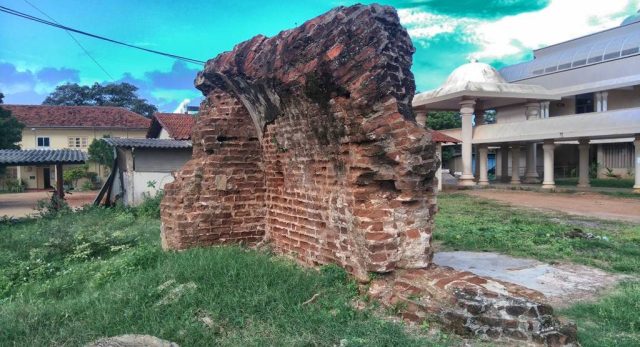
By Mahimsan (Own work) [CC BY-SA 4.0], via Wikimedia Commons
The fort at Mullaitivu was built by the Dutch in 1715 was originally a small wooden structure, in 1721 a quadrangular fort of earth-work has been erected. The English had rebuilt it during the British occupation of the island.
On 25 August 1803, the fort of was overrun by Vanni Bandara (Pandara Vanniyan), the last chieftain of Vanni, with the support from kingdom of Kandy. Lt. von Driberg of occupying British forces and his garrison was was driven away and the canons of the fort captured.
The exact location of the fort has been lost in time but remains of an massively thick ancient brick structure in the premises of the newly built Mullaitivu District Secretariat building is thought to be part of a building in this lost fort.
Also See
- Forts and Fortifications of Sri Lanka
- Ancient Heritage Sites of Sri Lanka
- Other Places of Interest Within Close Proximity
Map of Mullaitivu Fort
The map above also shows other places of interest within a approximately 20 km radius of the current site. Click on any of the markers and the info box to take you to information of these sites
Zoom out the map to see more surrounding locations using the mouse scroll wheel or map controls.
Driving Directions to Mullaitivu Fort
| Route from Colombo to Mullaitivu |
| Through : Puttam – Anuradhapura Distance :350 km Travel time : 7 hours Driving directions : see on google map |
0-09 m (87) 10-19 m (77) 20-29 m (46) 30-39 m (50) 40-49 m (24) 50-99 m (49) Ambalama (161) Ancient Anicuts (33) Articles (0) Asanaghara (8) Ashtapala Bodhi (5) Attraction Articles (3) Attractions (226) Beaches (9) Biosphere Reserves (3) Botanical Gardens (5) Bridges (34) Cave Art (6) Caving (7) Churches (17) Cities (9) Destinations (16) Dethis Pala Bodhi (15) Devalaya (41) Events (2) Flora and Fauna (76) Forts (49) Heritage (1629) Heritage Articles (28) Historic Events (5) History (7) Hot Springs (9) Hydro Heritage (87) Irrigation Articles (4) Islands (15) Kovils (25) Kuludage (11) Lighthouses (27) Memorials (53) Mile Posts (6) Mosques (3) Museums (8) National Parks (22) over 100 m (20) Pabbatha Vihara (11) Personalities (7) Pillar/Slab Inscriptions (37) Pre Historic Burial Sites (19) Prehistory (38) Prehistory Articles (2) RAMSAR sites (6) Ravana (12) Reservoirs (48) Rock Inscriptions (9) Ruins in Wilpattu (5) Ruins in Yala (25) Santuaries (7) Sluice Gates (13) Stone Bridges (18) Strict Nature Reserves (3) Sumaithangi (3) Survey Towers (15) Tampita Vihara (240) Tourist Attractions (198) Travel (3) View Points (18) Walawwa (13) War Memorials (26) Waterfalls (375) Wildlife Articles (24) Yathuru Pokuna (4)
Abhayagiri Monastery (20) Ampara District (193) Anuradhapura District (212) Badulla District (118) Batticaloa District (22) Colombo District (79) Galle District (64) Gampaha District (60) Hambantota District (117) India (1) Jaffna District (72) Kalutara District (51) Kandy District (201) Kegalle District (158) Kilinochchi District (13) Kingdom of Anuradhapura (85) Kingdom of Kandy (14) Kingdom of Kotte (9) Kingdom of Polonnaruwa (55) King Kavan Tissa (1) King Mahasen (1) King Walagamba (3) Kurunegala District (172) Maha Vihara (14) Mannar District (47) Mannar Island (10) Matale District (86) Matara District (44) Mihintale (22) Monaragala District (101) Mullaitivu District (21) Negombo (5) Nuwara Eliya District (117) Polonnaruwa District (119) Puttalam District (37) Ratnapura District (161) Trincomalee District (49) Vavuniya District (31) waterfalls in Sinharaja (3) z Delft 1 (5) z Jaffna 1 (20) z Jaffna 2 (24) z Jaffna 3 (12)

